Tag Archives: wheelchair

Interpretations of accessibility

To misquote the late queen “interpretations of accessibility may vary”… they have certainly varied at Newborough over the last decade.

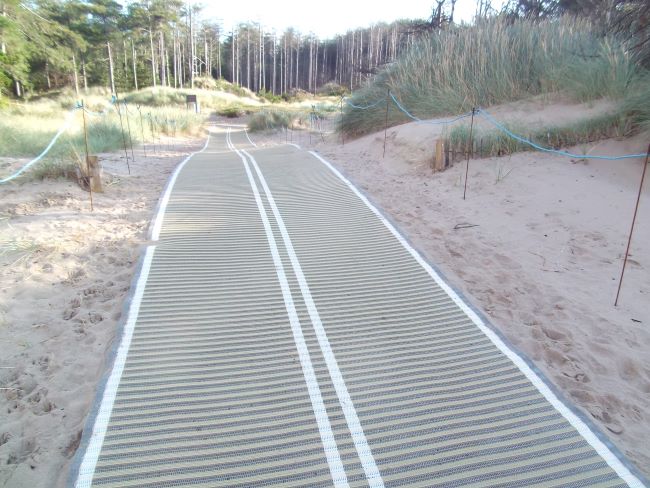
Inevitably, it only took a few days for the mobimats to start getting covered in sand and undermined: it’s more of a scary challenge, needing lots of strength, than an easy push to try and get a wheelchair (or pushchair) along the mats. And best keep away from the edges else you’ll likely tip over.

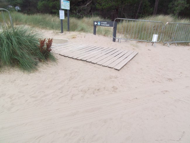
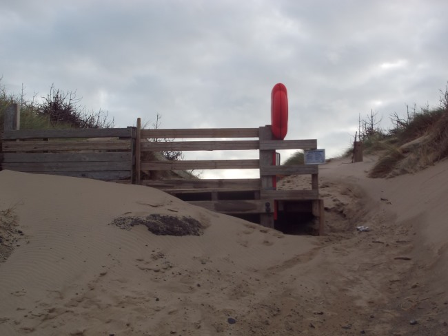
It’s ironic that the location chosen for the mobimats used to be a popular walkthrough to the beach, but a few years ago NRW fenced it off to prevent access. That fence gradually got covered by sand, until this year, you couldn’t even see it anymore. So, a few weeks ago, they dug out and chopped off a bit of the fence to put the mobimats down.

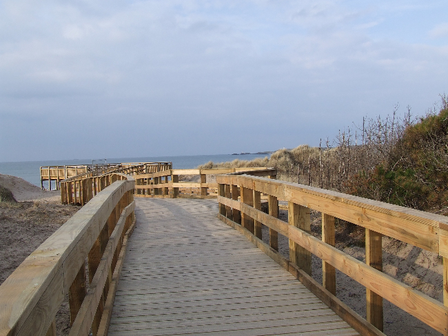
A further irony is that the newly installed life ring buoy at the end of the old boardwalk is now more inaccessible than ever.

Lifering buoy inaccessible
Inaccessible life ring buoy at the end of the now closed boardwalk (the sign says “boardwalk closed” and to use a different route).

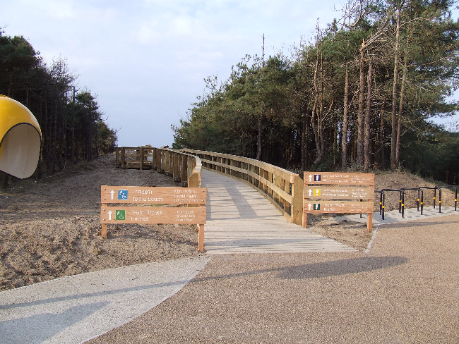
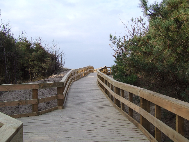
It’s fair to say that the original super-deluxe wooden boardwalk with viewing platform was a bit of a white elephant, but it was nice while it lasted. And at least it provided genuine accessibility with a place to sit and see the view.

The mobimat access point has an explanatory sign by it – a lot of words basically to say it’s a difficult environment to provide access in, so this is the best we can do (which I understand to mean a box has been ticked)…

Sign (after rain) to explain the rationale behind the mobimat access

Update: January 2024
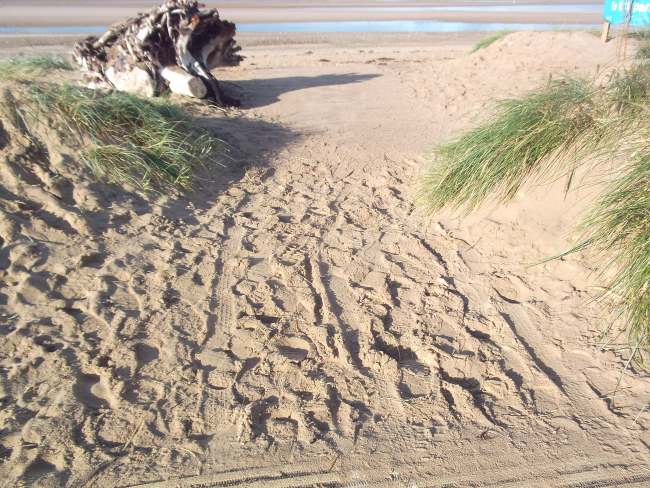
The mobimat has been moved a little further along the beach (a little further away from the main car park). It is more firmly bedded in; more easy to access off the forest track; but it still ends just at bare sand, so a regular wheelchair easily becomes stuck.

A better bird hide…

Improvements to the bird hide at Llyn Rhos Ddu, the little lake by the Marram Grass car park, are finished.

Llyn Rhos Ddu bird hide - outside

Llyn Rhos Ddu bird hide – outside

Some beautiful timber has been used to make new shutters, a bench and a porch. This means the hide is more easily accessible – you no longer have to slide the heavy door out of the way.

The inside of the hide with its new bench, shelf and shutters

The inside of the hide with its new bench, shelf and shutters

The hide is easily reached from the car park: it’s only about 30m along a level path and there is space for wheelchairs inside. It’s a great place for watching swans, herons, egrets, ducks and coots.

Today was incredibly windy and although all the coots, ducks and swans were facing one way, they were being blown in the opposite direction by the wind :)

Today was incredibly windy and although all the coots, ducks and swans were facing one way, they were being blown in the opposite direction by the wind :)


Like ducks (or coots, or geese or swans) to water…

The good weather at the weekend saw lots of this year’s baby birds take to the water for their first swims.

A trio of cootlings with their fuzzy little red top knots

A trio of cootlings with their fuzzy little red top knots

baby coots

Mother (and father) goose with six goslings

Mother (and father) goose with six goslings

This pair of mute swans only have a solitary cygnet, but they're giving it their full love and attention :)

This pair of mute swans only have a solitary cygnet, but they’re giving it their full love and attention :)

solitary cygnet

Funnily enough, there weren’t actually any ducklings about!

All these photos were taken from the Lon Las Cefni, close to the point where it joins the path that comes from the small Cors Ddyga car park near Pentre Berw. Both paths have recently been upgraded and it is possible to park at Cors Ddyga and get up to the Lon Las Cefni with a wheelchair (as long as there is somebody to help with the gates – they’re wide, but not easy to manage). The car park is signposted from the A5 just past Pentre Berw, heading towards Llangefni. The approximate grid reference is SH4617772627.

This is the sign at the (very small) parking area, showing the footpaths (and where German bombs fell during WWII!)

Lon Gors information sign Malltraeth Marsh

Malltraeth Cob

Malltraeth is the next village along from Newborough to the north. The two villages are linked by a “cob” – a dike wall – with a footpath/cycle track along its top.

Malltreath cob - the pools on the left and the sea on the right

Malltreath cob – the pools on the left and the sea on the right and very faintly in the background, the mountains

The cob was completed in the early 19th Century, under the direction of Thomas Telford and John Rennie. At the same time, the Afon Cefni was straightened (and straitened) creating what looks like a canal, but is still tidal. This created nearly 1,600ha of grazing land on either side of the Cefni. Much of this land is now a nature reserve managed by the RSPB.

The Afon Cefni at high water

The Afon Cefni at high water

From the cob there are beautiful views in all directions. On the inland side, lie a series of pools, known as the Cob Pools, with the vast Malltraeth Marsh / Cors Ddyga beyond. To the seaward side are the Malltraeth Sands with Malltraeth Bay beyond. The whole area is a haven for wildlife, particularly birds.

One of the benches looking out over the Cob Pools, across the marshes to the mountains beyond

One of the benches looking out over the Cob Pools, across the marshes to the mountains beyond

At the Malltraeth end of the cob, there are several benches and a small picnic area (and a chip shop in the village). There are also information boards explaining the history of the cob and the geology of the area, as well as a visual guide to help you identify the mountain peaks that form the horizon to the south.

Malltraeth parking area looking out towards the bay

Malltraeth parking area looking out towards the bay

At the Newborough end of the cob, there is another small car parking area, with picnic benches, known as the Malltraeth car park.

The path on the cob is completely flat. From one end to the other it is about a mile long.

Lots more information about the cob, Malltraeth and the history of the area can be found on the Malltraeth village website: www.malltraeth.com

One of the information boards at Malltraeth

One of the information boards at Malltraeth

Access for all

**please see bottom of page for important more up to date information**

Over the winter, an awful lot of work has been taking place in Newborough Forest. A new easy access trail for wheelchair users is one part of the works. The trail, a wooden boardwalk, provides access to an elevated viewing platform giving stunning views across the beach.

The start of the new easy access trail

The start of the new easy access trail

First glimpse of the sea

First glimpse of the sea

The new viewing platform with picnic tables and beautiful views

The new viewing platform with picnic tables and beautiful views

Work on the trail is very nearly completed and it is open for use while the final finishing touches are put in place.

The work has been done by Jones Bros, working through a bone numbingly cold winter, so fair play to them. Chwarae teg.

Jones Bros banner

Jones Bros banner

The boardwalks and viewing platform nestled into the edge of the forest, with Snowdonia in the background

The boardwalks and viewing platform nestled into the edge of the forest, with Snowdonia in the background

NB: the main viewing platform was destroyed in high tides back in 2014. Since then, the boardwalk that led to it has got progressively shorter and shorter. It is often covered by blown sand and usually impossible to push a chair along:( So much for access for all.

Update 2023
The boardwalk dwindled to a tiny stub of its former self. It was never cleared of sand. In summer 2023 the little that remained of it was closed off to visitors.